DSN WIRESUN 11 OCT 20260419 UTC
World
ANALYSISA new nocturnal thunderstorm cell crawled over London on the night of June 23, 2026, generating thousands of lightning strikes as cloud tops plunged below -65°C.
FILED 4 MIN READ
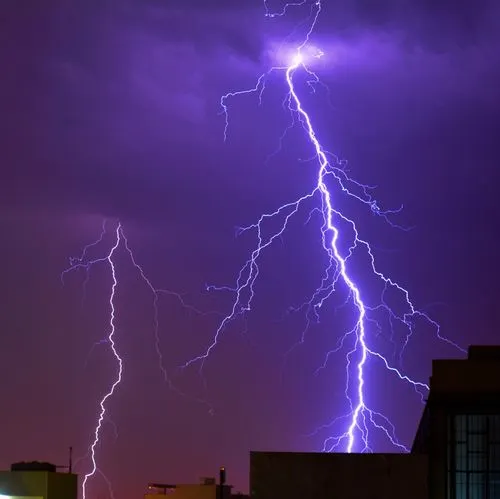
London, United Kingdom — June 23, 2026
London cannot catch a break. For the second consecutive night, a violent nocturnal thunderstorm cell has swept over the British capital — generating thousands of lightning strikes, sparking house fires and flooding roads as one of the most intense and unusual weather events in the city's recent history continues to unfold.
A new, nocturnal thunderstorm cell is currently crawling over the city of London with tons of lightning strikes ongoing as the storm's cloud top temperatures drop below -65°C (-85°F). Cloud tops at that temperature indicate an extraordinarily powerful and energetic storm — the kind of atmospheric event that meteorologists classify as a deep convective system, capable of producing intense and frequent lightning, large hail, gusty winds and sudden, heavy downpours.
Spectacular thunderstorms swept across London overnight, causing thousands of lightning strikes and flash flooding. The storms battered the capital for more than two hours, waking thousands from their sleep as torrential rain filled roads with water. The thunderstorm cell erupted overnight catching forecasters by surprise as it generated thousands of lightning strikes. Londoners shared stunning video clips of the lightning which was observed in all corners of the capital.
The lightning is believed to have caused two house fires as London Fire Brigade took hundreds of calls through the night. London Fire Brigade has taken around 400 calls since midnight after a series of intense thunderstorms struck the capital. Firefighters across the city have been responding to numerous flooding calls, mostly affecting properties.
Assistant Commissioner Pat Goulbourne said: "It has been a very busy night for our Control Officers, firefighters and officers. Shortly after 0400 hrs, due to a large number of calls received by the Brigade, we implemented our High-Volume Call procedure which means flooding calls where there is a risk to life are prioritised."
Some areas were also hit by flash flooding including roads. One person on X posted videos of flash floods in Ruislip, west London, writing: "I've not seen anything like this in years in London. The whole road from the Polish War Memorial up to Ruislip was basically under water."
The extreme cloud top temperatures — dropping below -65°C — are a key indicator of just how powerful this thunderstorm system is.
When cloud tops reach such extreme altitudes and temperatures, it signals that the storm's updrafts are carrying moisture and energy to extraordinary heights in the atmosphere. The result is a system capable of producing intense and frequent lightning, heavy rainfall in short bursts and — in some cases — large hail and tornado-like wind gusts at the surface.
Meteorologists say the dramatic weather is the result of a classic "thundery breakdown" following prolonged extreme heat. Much of southern and eastern England had been under an amber heat warning as temperatures climbed into the mid-to-high 30s Celsius over the past several days. The prolonged spell of hot, humid conditions created an unstable atmosphere packed with energy. When cooler air began moving into the region, that energy was released violently through thunderstorms capable of producing intense lightning, loud thunder and heavy downpours.
This second storm arrives after a dramatic first night of thunderstorms on June 22–23 that lit up London's skies in spectacular fashion. Residents described being woken by bright bursts of light shining through curtains and windows, with some describing their bedrooms lighting up "like daylight." Social media was flooded with reactions — with users comparing the scene to an alien invasion, a science-fiction movie and the apocalypse.
Journalist Adam Schwarz captured orange lightning lighting up London's pre-dawn sky. "Dawn has broken over London and there's now some spectacular orange lightning towards the east," he wrote.
Transport bosses warned people against all but essential travel amid the ongoing weather disruption.
Perhaps most remarkably — despite two consecutive nights of violent thunderstorms — the heatwave that triggered all of this is still arriving.
A red weather warning for extreme heat covering an area stretching from London to Swansea and Somerset to Birmingham has been issued by the Met Office from 9am on Wednesday to 9pm on Thursday. These are reserved for the most severe events, the Met Office said, meaning this heatwave is expected to bring "severe and significant impacts" including widespread health risks for many, not just those who are normally more vulnerable to the heat.
Temperatures for the latest heatwave are likely to overtake the June record set in Hampshire in 1976 by several degrees and could come close to the UK's all-time high of 40.3°C which was measured in July 2022.
The hot conditions will be accompanied by high humidity and very warm nights, which will make it hard for people to recover overnight, the Met Office warned.
London and much of southern England now faces an extraordinary sequence: two nights of violent thunderstorms, followed by a red-warning heatwave that could push temperatures toward 40°C by Wednesday and Thursday. The combination of exhausted infrastructure, flooded roads, fire-damaged buildings and extreme incoming heat creates a perfect storm of challenges for emergency services, transport networks and public health systems.
DeSanta News will continue to follow London's extreme weather situation throughout the week.
Subscribe to get the latest articles delivered to your inbox.
No comments yet. Be the first to share your thoughts.
World

World

World